Document

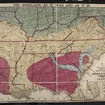
Lloyd's New Military Map of the Border and Southern States
Lloyd's New Military Map of the Border and Southern States. Lloyd’s New Military Map of the Border and Southern States from 1865 provides a clear example of the territory held by the Confederate and Union Armies at the end of the Civil War. The red parts indicated Confederate territory, now very much reduced compared to the other maps, the yellow parts show areas gained by the Union Army since early January 1862 and the blue part shows the route taken by General Sherman’s troops during their march through the South. The green indicates the Union. This map highlights how divided the Border States were with portions of Missouri and Kentucky coloured to indicate Union occupation. Although these both remained in the Union, internal civil struggles threatened to divide the states and Lincoln campaigned hard to ensure these states remained together. By comparison, Virginia witnesses an internal secession in 1863 and West Virginia can clearly be seen here on this map as part of the Union. This map is one of the best maps in the collection that detail how far the Union Army went into occupying the Confederate states and reuniting the country.
The British Library1865

