Document

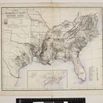
Map, showing the Distribution of Slaves in the Southern States. Projected and compiled by A. von Steinwehr.
Map, showing the Distribution of Slaves in the Southern States. Projected and compiled by A. von Steinwehr. This map shows the breakdown of slave-ownership by each county with the darker colour indicating a higher percentage of slaves. The map includes a smaller depiction of where the majority of cotton and sugar production occurred. The map thus shows the extent of the slave system before the war. Von Steinwehr was German-born general in the Union Army who fought at many of the war’s prominent battles, including the First Battle of Bull Run and the Battle of Gettysburg. Alongside fighting, he was a keen cartographer, as this map demonstrates.
The British Library1861

