Dokument

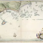
"The ground plott of the Towne [of St. Peter's] and Castle Cornet, with the rocks and soundings thereof; truly layd down as they wear survey'd and measured by T.P., anno 90;" drawn by Thomas Phillips, on a scale of 135 yards to an inch.
This manuscript map of 1680 depicts Saint Peter Port and the rocky harbor on the east coast of the island of Guernsey. The document is one from a larger report prepared for King Charles II in 1680-81: 'THE PRESENT STATE of Guernsey with a short accompt of Iersey and the Forts belonging to the said Islands, by Col nll George Legge [Baron Dartmouth, 1682], Lieutenant-General of His Ma ties ; Ordnance', 1680, with elaborately-coloured title-page enclosing, at the head, the royal arms and, at the foot, arms and crest of Legge, and many charts, plans, and views of Guernsey, Jersey, and Sark by Thomas Phillips, Engineer. On f. 2 is the letter of Col. Legge, dat. 9 Jan. 16 80 / 81 , presenting the report to King [Charles II].
The British LibraryThomas Phillips
1680

